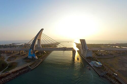
Dapeng Bay is the largest inner-bay lagoon in Taiwan, with a water area of about 532 hectares, separated from the Taiwan Strait by a natural sandbar to form a calm, enclosed body of water. During the Japanese colonial era it served as a naval seaplane base — a seaplane training field was built in 1938 and the Donggang Naval Air Group was established in 1940. Designated Taiwan's fourth national scenic area by the Tourism Bureau in 1997, it has since developed water recreation facilities and is now one of southern Taiwan's key sailing and water sports bases.
Dapeng Bay's water area covers about 532 hectares, with total land, water, and sea area of roughly 1,438 hectares; a seaplane training field was built here in 1938 and the Donggang Naval Air Group was established in 1940 during the Japanese colonial era, before the area was designated Taiwan's fourth national scenic area by the Tourism Bureau in 1997.
Highlights of Dapeng Bay National Scenic Area
The Dapeng Bay water area is calm and little affected by offshore wave conditions, making it suitable for sailing, kayaking, jet skiing, banana boating, and various other water sports. The lakeside cycling route is about 13 kilometers in total, circling the lagoon; along the way you can enjoy mangrove forest ecology, aquaculture fish ponds, and the distant ridgeline of Dawu Mountain — a rare low-lying lakeside cycling experience on Taiwan's southwestern coast.
On the northeastern side of the bay there is a marina where various sailboats and yachts are moored. Some military structures are preserved in the surrounding area, such as the seaplane hangar, now used as an exhibition and creative culture space. Dapeng Bay is close to Donggang, making it easy to combine with Donggang seafood and the bluefin tuna season (April to June) — an important node on the Pingtung coastal itinerary.
How to make the most of your visit
Practical information
Getting there and timing
- There is no direct public transport. Self-driving or taking a taxi from Donggang is recommended; the journey from Donggang town to Dapeng Bay takes about 10 to 15 minutes.
- The scenic area is open all day; water sports operators have their own operating hours. Water activities may be suspended during strong winds or rainy season — confirm in advance.
- In summer, high temperatures make it advisable to be active between 8 and 10 a.m. or after 4 p.m.; sun protection is essential.
Nearby connections
- Donggang Gongrong Market is about 10 minutes from Dapeng Bay by car; you can buy bluefin tuna sashimi, grey mullet roe (wuyuzi), and other fishing port specialties there.
- To take the ferry from Donggang to Xiao Liuqiu, you need to go to Donggang pier; please check the latest schedules from official sources or the ferry companies.
Sources: Dapeng Bay National Scenic Area Administration official website. Water sports are affected by weather; for actual operating conditions, please confirm with on-site operators.
Frequently Asked Questions
How large is Dapeng Bay's water area?
Dapeng Bay's water area covers about 532 hectares, making it Taiwan's largest inner-bay lagoon.
What was Dapeng Bay used for during the Japanese colonial era?
It served as a naval seaplane base, with a training field built in 1938 and the Donggang Naval Air Group established in 1940.
When was Dapeng Bay designated a national scenic area?
It was designated Taiwan's fourth national scenic area by the Tourism Bureau in 1997.
Sources
- 大鵬灣國家風景區 - 維基百科 — 1997年成立、陸海水域面積數據
- 大鵬灣原日軍水上飛機維修廠-南棟、北棟 — 文化部文化資產局,1938年水上飛機訓練場、1940年東港海軍航空隊