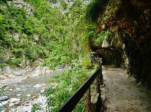
Shakadang Trail is a hiking path carved into the Shakadang River gorge in Taroko National Park, officially listed at 4.4 km with a one-way walk of about 2 hours. Originally called Mystery Valley Trail and built in the late Japanese colonial era for a hydropower project, it was formally renamed "Shakadang" — an indigenous word for "molar" — in 2001, with trailside signage added in the Truku language.
Shakadang Trail runs 4.4 km along the Shakadang River gorge inside Taroko National Park, with a one-way walk taking about 2 hours. Originally called "Mystery Valley Trail" and built in the late Japanese colonial period for a hydropower development plan, it was officially renamed "Shakadang" in 2001 — from the indigenous word "sgadan," meaning "molar." Truku-language interpretive signage was added at the same time. A marker called "Wujianwu" (Five Houses) sits around the 1.5 km point, and the trail ends at the ruins known as "Sanjianwu" (Three Houses).
Highlights of Shakadang Trail
"Shakadang" is a Truku word meaning "molars," describing the shape of the rocks in the canyon. The trail entrance is located beside the Taroko Tunnel, and the route follows the Shakadang River closely throughout. The riverbed's marble pebbles have been ground and polished by centuries of water flow, displaying a mosaic of white, gray, brown, and banded colors that shift constantly with the angle of light. The river water, infused with minerals from the rock layers, takes on a distinctive blue-green tint on sunny days.
The trail is rich in wildlife. Formosan macaques, Swinhoe's pheasants, and Emerald tree frogs can sometimes be observed at close range during the early morning and dusk hours. Stalactite formations and moss growth are visible on the cliff walls at covered-tunnel sections where water seeps through. The trail ends at the ruins of the Sanjian House (Three Houses) settlement; a one-way walk takes approximately 1.5 to 2 hours. You can continue as far as your energy allows or choose your own turnaround point.
Tips for Getting the Most Out of Your Visit
Practical Information
Getting There & Time
- The trail entrance is beside the Taroko Tunnel, about a 40-minute drive from Hualien City. Alternatively, take the Taroko National Park shuttle bus to the trail entrance.
- The trail is 4.4 km long; a one-way walk takes approximately 1.5 to 2 hours, and the full round trip takes about 3 to 4 hours. Bring enough water and a light snack.
- Trail access can change due to weather or geological events. Always check the Taroko National Park official website (www.taroko.gov.tw) before setting out.
Nearby Connections
- Shakadang Trail is close to the Taroko Gorge's Swallow Grotto and Jiuqudong trails. A natural day plan is Shakadang Trail in the morning and the gorge trails in the afternoon.
- The Taroko Visitor Center is nearby — stop in to pick up maps and the latest trail information before heading out.
Sources: Taroko National Park Headquarters official data.
Frequently Asked Questions
How long is Shakadang Trail?
The trail is officially listed at 4.4 km, with a one-way walk taking about 2 hours.
What does the name "Shakadang" mean?
It comes from the indigenous word "sgadan," meaning "molar," and was formally adopted in 2001.
Where does Shakadang Trail end?
The trail ends at the ruins known as "Sanjianwu" (Three Houses), passing the "Wujianwu" (Five Houses) marker around the 1.5 km point.
Sources
- 砂卡礑步道 - 花蓮觀光資訊網 — 步道長度4.4公里、單程時間等官方資訊
- 砂卡礑步道 - 維基百科 — 2001年更名沿革、原住民語意義、五間屋三間屋等地標