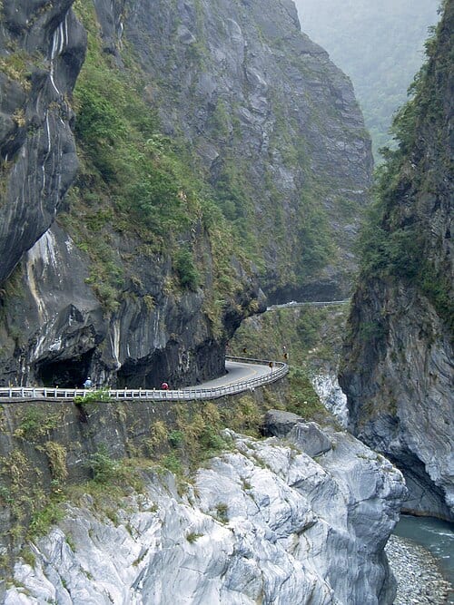
Taroko Gorge is a deep canyon carved by the Liwu River through marble bedrock, with a depth exceeding 1,000 meters, forming the core landscape of Taroko National Park, most spectacular at the Swallow Grotto and Jiuqudong sections.
The marble that forms Taroko Gorge originated as limestone deposited from biological remains during the late Permian period (roughly 250 million years ago), before being metamorphosed into marble by the Nanao orogeny about 70–80 million years ago. The gorge is a V-shaped canyon with a depth exceeding 1,000 meters, shaped by the Liwu River's continuous downcutting combined with Taiwan's ongoing tectonic uplift, which exceeds 0.5 cm per year in the area.
Highlights of Taroko Gorge
The rock layers of Taroko Gorge are predominantly marble, and the exposed faces display a shifting range of whites, grays, and pale blues depending on light and water. The Liwu River rushes along the base of the canyon, its water clear enough to reveal the boulders on the riverbed below. The depth of the gorge and the angle of the cliff walls create dramatically different visual effects at different times of day: direct midday sunlight reaches the canyon floor, while late-afternoon side-lighting brings out the three-dimensional texture of the rock grain.
At Swallow Grotto, Pacific swallows (rock swallows) nest in hollows in the cliff face, and you can watch them in flight. The Jiuqudong trail takes its name from the winding terrain; the tunnel is cut directly through sheer cliff, and walking through it gives a powerful sense of geological scale. Some trails may be temporarily closed due to geological instability or ongoing construction work. Before setting out, always check the Taroko National Park official website for current trail conditions and whether an entry permit is required.
Tips for Getting the Most Out of Your Visit
Practical Information
Getting There & Time
- Taroko National Park is located in Xiulin Township, about a 30–40-minute drive from Hualien City to the Taroko Visitor Center. For road and trail conditions, check the official website before departure (www.taroko.gov.tw).
- The Swallow Grotto trail takes about 1 hour round trip; the Jiuqudong trail also takes about 1 hour round trip. If you plan to cover multiple trails, allow a half to a full day.
- Midday is the hottest and most crowded period. Arriving before 8 a.m. or after 3 p.m. helps you avoid crowds and enjoy better lighting conditions.
Nearby Connections
- The Taroko Visitor Center is located near the gorge entrance and provides maps, interpretive materials, and trail information. It's worth stopping here before heading into the gorge.
- Shakadang Trail is located near the Taroko Tunnel entrance and can be combined with a gorge hike for a half-day or full-day deep dive into the Taroko area.
Sources: Taroko National Park Headquarters official data.
Frequently Asked Questions
How deep is Taroko Gorge?
Taroko Gorge is a V-shaped canyon with a depth exceeding 1,000 meters.
How did the marble in Taroko Gorge form?
The marble began as limestone about 250 million years ago and was metamorphosed by the Nanao orogeny roughly 70–80 million years ago.
Is Taroko Gorge still changing?
Yes — the area's crust rises more than 0.5 cm per year, and the Liwu River continues to cut downward, gradually deepening the gorge.
Sources
- 太魯閣國家公園管理處 - 地理小檔案 — 峽谷深度超過1,000公尺、地殼抬升速率
- 大南澳片岩:太魯閣帶的變質事件與中生代大地構造演化 - 臺灣地質知識服務網 — 大理岩形成年代、南澳運動變質作用