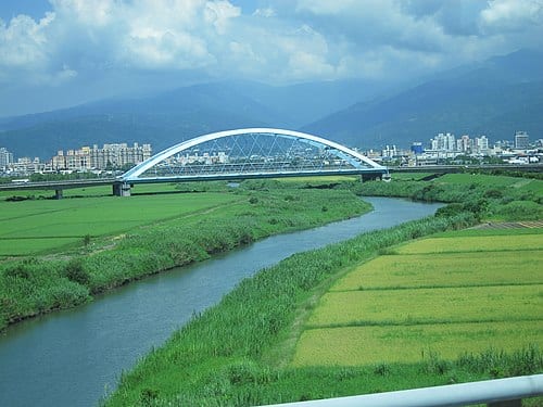
Yilan Riverside Park is a linear leisure space built along the Yilan River embankment, running through Yilan City. The Yilan River is 25 km long, rising from Dajiaoxi Mountain and Xiaojiaoxi Mountain in the Snow Mountain Range, and is a tributary of the Lanyang River with a drainage basin of about 149 square kilometres. The park has cycling paths, lawns, and viewing platforms; on clear days you can see the farmland across the river and the distant silhouette of the Snow Mountain Range, and once the evening lighting comes on, it becomes a popular spot for locals out for a night stroll.
The Yilan River is 25 km long, rising from Dajiaoxi Mountain and Xiaojiaoxi Mountain in the Snow Mountain Range on the border of Jiaoxi Township, Yilan and Wulai District, New Taipei. It is a tributary of the Lanyang River with a drainage basin of about 149 square kilometres, flowing through Yilan City and Zhuangwei Township before joining the Lanyang River near the Kavalan Bridge and emptying into the Pacific Ocean.
Highlights of Yilan Riverside Park
The Yilan River is the main waterway running through Yilan City; the park-style development of the riverbank gives residents easy access to the waterfront. The park extends along multiple sections of the river through Yilan City and is entirely flat, making it suitable for strollers and older visitors. The top of the embankment has a cycling path with open views — on a clear day you can see the Snow Mountain Range along the western edge of the Yilan Plain, with wide-open farmland and mountains as the backdrop.
The riverside park sees heavy use from local residents: morning walkers in the early hours, families and children in the evening. The evening lighting is primarily warm-toned, creating a pleasant atmosphere — though it is designed mainly for pedestrian safety rather than as a tourist night-view attraction. The park has a modest amount of rest facilities and is, overall, an everyday leisure park.
How to Make the Most of Your Visit
Practical Information
Getting There
- The park runs along the Yilan City riverbank; the main entrance is about a 10–15-minute walk from Yilan Train Station.
- Drivers can use roadside parking bays along the embankment or nearby public car parks; spaces are limited on weekends.
- Open year-round, free of charge. Early morning and late afternoon see the most visitors; midday is quieter.
Nearby Connections
- Zhaoying Temple and Yilan Governance Memorial Hall in Yilan's old city area are within walking distance of the riverside park and can be combined into a pedestrian historical-district itinerary.
- Yilan City's dining options are concentrated along Zhongshan Road — convenient for a meal after your walk.
Source: Yilan City Office and on-site observations.
Frequently Asked Questions
How long is the Yilan River?
It is 25 km long, rising from Dajiaoxi Mountain and Xiaojiaoxi Mountain in the Snow Mountain Range.
Can you see the Snow Mountain Range from the riverside park?
On clear days, the embankment's viewing platform offers a view of the Snow Mountain Range to the west, most striking in winter when the peaks are snow-capped.
Is the riverside park open year-round?
Yes, it's open year-round and free of charge; early morning and evening see the most visitors, with midday being quieter.
Sources
- 宜蘭河 - 維基百科 — 全長25公里、發源地雪山山脈、流域面積149平方公里