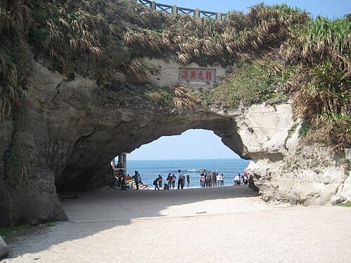
Shimen Cave is a natural sea-arch in Shimen District, New Taipei, formed by long-term wave erosion combined with land uplift; the arch stands about 10 meters tall and now sits above sea level. At high tide, waves surge through the opening; at low tide, the exposed cave floor lets light stream in — two starkly different sights. The nearby Shimen Windmill Park can be paired with the cave for a coastal stop where geology and wind energy share the same view.
The arch at Shimen Cave, shaped by wave erosion and land uplift, now stands about 10 meters tall at the 28.7 km marker of Provincial Highway No. 2; the district name Shimen (Stone Gate) derives directly from this sea-arch, first recorded in the 1694 Fujian Tongzhi gazetteer, which describes a stone with a round hole through it like a gate.
What to see at Shimen Cave
Shimen Cave is a sea cave formed by long-term wave erosion of the sandstone along the north coast. The arch-shaped opening is tall enough for people to walk through. Depending on the tide, the appearance at the mouth differs markedly: at low tide, the rock platform on the cave floor can be approached at close range; at high tide, waves rush inside and the splashing spray is a popular photography subject. The arch framing can be captured from both the east and west sides of the cave mouth.
Shimen Cave is right next to Provincial Highway No. 2; a few minutes' walk reaches the Windmill Park, which has several large white wind turbines. The strong north coast winds are made tangible here. The reef terrain along the Shimen coast is rich; during the autumn and winter northeast monsoon season, waves are stronger than in summer — more dramatic scenery, but take care.
How to make the most of your visit
Practical information
Getting there and timing
- Drive along Provincial Highway No. 2 (North Coast Road). Shimen Cave has a car park with a clearly marked entrance.
- Public transport: buses from Taipei Bus Station to Shimen, or take a bus from Danshui along the north coast route.
- No fixed opening hours, but the cave floor is unsafe at high tide or with large waves. Avoid visiting during typhoon or strong wind warnings.
Nearby connections
- Shimen Windmill Park is within walking distance. Continue east to reach Jinshan Old Street and Jumping Stone Coast.
- Heading west connects to Sanzhi and Danshui, linking the entire north coast route.
Source: New Taipei City Government Tourism and Travel Bureau, Shimen District information.
Frequently Asked Questions
How did the arch at Shimen Cave form?
Shimen Cave is a sea-arch shaped by long-term wave erosion of sandstone combined with land uplift; the arch now stands about 10 meters tall.
Is the Shimen place name related to the cave?
The district name Shimen (Stone Gate) derives from this sea-arch, first recorded in the 1694 Fujian Tongzhi gazetteer, which later gave its name to the local administrative area.
How does Shimen Cave differ at high and low tide?
At high tide, waves rush directly into the cave with splashing spray; at low tide, the exposed rock platform on the cave floor can be viewed up close.
Sources
- 北海岸及觀音山國家風景區管理處—石門洞 — 石門洞高度約10公尺、台二線28.7公里處
- 石門區 - 維基百科 — 石門地名源自石門洞,1694年福建通志記載